↓
 

Sylacauga Land Surveying

Your Choice for Surveying in Sylacauga, AL.....

Sylacauga Land Surveying Header
Sylacauga Land Surveying
  • Home
  • ALTA Survey Sylacauga, AL
  • Civil Engineering
  • Drone LiDAR Mapping
  • Elevation Certificate
  • Land Surveying
  • Property Survey – Boundary Survey
  • Topographic Survey | Topo Survey
  • Contact Us
  • Blog
Home 1 2 3 >>

Post navigation

← Older posts

Property Survey Cost Before Dividing Inherited Family Acreage Among Heirs

Sylacauga Land Surveying Posted on September 7, 2026 by Sylacauga SurveyorSeptember 2, 2026
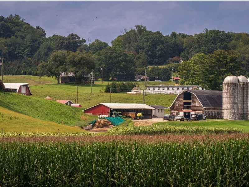
Rural family acreage with farmland and buildings considered during a property survey cost review in Sylacauga Alabama.

Property survey cost is one of the first questions families ask when they inherit land together. A parent passes down a piece of acreage, and now three or four siblings own it as one. Before anyone can split that land into separate parcels, a surveyor has to measure it, mark it, and draw new lines on paper. That work takes time. And the price often surprises people who expected a simple, single-tract survey.

dividing inherited land among heirs usually costs more than surveying that same land for one owner. The reason isn’t complicated. More owners often means more lines, more parcels, and more decisions to work through before the survey crew even shows up. 

How the Number of Heirs Changes the Survey Scope

When one person owns a piece of land, a surveyor may begin with a boundary survey to confirm the outer limit of the existing tract. That establishes the property being divided before any new parcel lines are laid out. 

Inherited land split among heirs works differently. Say four siblings inherit sixty acres. If they want four separate parcels, the surveyor has to plan four sets of boundaries instead of one. Each new line has to connect to the others without gaps or overlaps. Each corner needs a marker. Each parcel needs its own legal description.

More heirs often means more proposed division lines. More division lines mean more fieldwork, more calculations, and more time spent drafting the final maps. That’s the core reason inheritance surveys can carry a different scope than a standard single-owner job. It’s not about the land being harder to measure. It’s about how many separate pieces the final result needs to be.

Why Unequal Inheritance Shares Can Require More Survey Planning

Not every inheritance splits evenly. Maybe one sibling gets forty percent because they cared for a parent in their final years. Maybe they will name specific dollar values instead of equal shares. These situations add another layer of planning.

A surveyor working with unequal shares can’t just divide the acreage into identical slices. The proposed parcels have to reflect the agreed percentages or dollar amounts, which usually means factoring in things like road frontage, usable land, and access. A ten-acre parcel near a paved road isn’t worth the same as a ten-acre parcel buried in a back corner with no direct access.

Getting these shares right takes extra layout work. The surveyor may need to run several drafts before the parcels match what the family actually agreed to. This kind of planning goes beyond marking a simple boundary line. It’s closer to solving a puzzle where the pieces need to add up to a specific value, not just a specific size.

Existing Roads, Homes, and Improvements Can Complicate the Family Division

Most inherited land isn’t empty. There’s often an old farmhouse, a barn, a gravel driveway, or a well that serves the whole property. These features matter a lot when heirs start dividing land.

Say one heir wants the parcel with the house. Another wants the barn. A third just wants open pastures. The surveyor has to work around these existing structures so each new parcel still makes sense on its own. A parcel that gets the house needs enough land around it to be usable. A parcel that shares a driveway with another parcel may need an access easement written into the survey.

Wells, septic systems, and shared utility lines add more complexity. If a single well serves the whole property, the family and surveyor need to figure out how that gets handled once the land splits four ways. These conditions can add measurement points and documentation the surveyor wouldn’t need if the land stayed as one tract.

More Proposed Parcels Can Mean More Field and Drafting Work

Every new parcel a family creates adds its own round of tasks. The surveyor has to measure new boundary lines in the field. Set new corner markers, called monuments. Calculate the exact acreage of each parcel. Write a legal description for each one. Draw a final map showing how all the pieces fit together.

Split one tract into two parcels, and you’ve roughly doubled some of that work. Split it into five, and the math adds up fast. This is the main reason property survey cost for an inheritance division often runs higher than a single-tract survey of the same total acreage. It’s not that the land itself changed. It’s that the paperwork, math, and fieldwork multiplied along with the number of parcels.

Some families try to cut corners here by asking for a rough sketch instead of a full survey. That can backfire later, especially if someone wants to sell their share or get a loan using the land as collateral. Lenders and title companies usually want a proper, recorded survey before they’ll move forward.

Get the Heirs’ Proposed Division Clear Before Requesting a Survey Quote

The best thing a family can do before calling a surveyor is agree on the basics first. How many parcels does everyone want? Roughly where should the lines go? Who gets the house, if there is one? Are there any existing deeds, old surveys, or estate documents that describe the land?

Bring this information to the first conversation with the surveyor. A clear plan, even a rough one, helps the surveyor understand the size of the job before they give you a number. Vague requests like “just split it evenly” tend to lead back-and-forth conversations and can slow down the quote process.

It also helps to walk the land ahead of time and note any features that might affect the split. A pond in the middle of the property, a shared driveway, or an old fence line that doesn’t match the deed can all shape how the parcels end up looking. The more the surveyor knows upfront, the fewer surprises show up once the work begins.
Posted in boundary surveying | Tagged boundary survey

Buying an Expandable Commercial Site? A Property Survey Should Come First

Sylacauga Land Surveying Posted on August 20, 2026 by Sylacauga SurveyorAugust 16, 2026
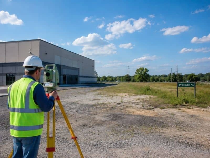
Property Survey for commercial site expansion in Sylacauga Alabama

A property survey answers the one question most buyers in Sylacauga, Alabama really care about. Can this land actually hold the expansion they picture? Open ground next to a building looks simple from the outside. But plenty of buildable-looking space hides conditions you cannot see. Those only show up once someone measures and records them. That is why the survey should come before the purchase, not after. It protects your money.

Many buyers pay for a site based on what they hope to build. That hope needs facts behind it. A survey provides those facts before you sign. It is a small cost next to the price of the land, and it can save you from a deal that was never going to work.

Expansion Depends on the Land Around the Building

Buyers who want to grow often focus on the current building. They treat the land around it as an afterthought. That skips the exact fact that decides if expansion is even possible. A property survey shows how the building relates to the rest of the site. It shows how much usable space really surrounds it.

Without that fact, buyers are guessing at their own future room to grow. A survey turns that guess into something you can measure and trust. That matters most before money changes hands, when you still have room to walk away from a bad deal.

The shape of the land matters too. A wide, open area may hold a new building with ease. A long, narrow strip may not, even at the same size. Only a survey shows the true shape. That shape decides what will really fit.

Is the Open Ground Actually Available for Construction?

Vacant-looking land is not always buildable land. Recorded easements, setback rules, or utility corridors can all sit quietly on paper. None of them show up as a visible sign on the ground. A property survey brings these conditions to the surface before they become a problem during design or permitting.

This step matters most for buyers counting on that open space to justify the price. Finding a restriction after closing is a costly lesson. Finding it beforehand is cheap. The survey lets you know what you are really buying.

An easement is a good example of a hidden limit. It may let a utility run lines across part of the lot. You still own that ground, but you may not be able to build on it. A survey maps where the easement sits, so you know which parts of the land are truly open.

Existing Buildings Set the Starting Point for New Design

Every expansion plan has to work around what is already built. A survey shows exactly where the current building sits. It maps the relationship to the property lines and other site features. That gives architects and engineers a solid starting point before they sketch anything new.

This is base information that shapes early design talks. Skip it, and early plans usually have to be redone once accurate numbers finally surface. That rework costs time you may not have during a purchase window. Better to have the facts up front.

The current building may also sit closer to a line than it looks. That matters if you plan to build next to it. A survey shows the real gap between the building and the edge, so designers know how much room they truly have.

What a Survey Should Clarify Before an Expansion Design

Before you commit to an expansion design, a few facts tend to matter most. 

These are the ones buyers and their design teams lean on early:

  • Overall site size and how it relates to the current building
  • Where existing improvements, parking, and access points sit
  • Recorded easements or utility corridors crossing the property
  • Layout details that affect where new work can be placed

Get these settled early, and you prevent costly redesigns that often hit after concept plans are already underway. Early answers keep the project cheap and smooth.

Using Survey Information During a Feasibility Review

A property survey is one piece of a larger review. It is not the whole picture on its own. Buyers usually pair it with zoning review, engineering input, utility research, and environmental checks before making a final call.

Each check answers a different question. Zoning tells you what the law allows. The survey tells you what the land can hold. Utility research tells you what services reach the site. Put together, they form a clear view. No single check gives you the full story alone.

The best time for all of this is during due diligence. That is the window before the deal closes, when you still have the power to renegotiate or walk away. Once you own the land, that power is gone. Order the survey while it can still change your decision.

Frequently Asked Questions

How does a survey change what I offer for a site? 

It tells you exactly how much usable land you are paying for. If hidden easements or setbacks shrink your buildable area, that fact should shape your offer. Buyers who skip this step sometimes pay full price for space they can never actually use.

Should I order a survey even if the seller already has one? 

It depends on how old that survey is and whether it fits your plans. Older surveys may miss recent changes to the site. A new survey scoped to your expansion idea gives you the most reliable answer.

What if the survey finds a problem after I am already under contract? 

This is exactly why the survey should happen during due diligence. Most purchase agreements give buyers room to renegotiate or exit the deal if a survey uncovers a serious issue before closing.

Posted in Property Survey | Tagged Property Survey

What Lies Beyond the Quarry Edge? A Better Way to Map Disturbed Ground

Sylacauga Land Surveying Posted on July 16, 2026 by Sylacauga SurveyorJuly 16, 2026
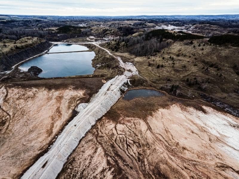
Drone flying above an abandoned quarry with terraced rock cuts, overgrown slopes, and uneven excavated ground.

Old excavation sites hide their shape well, and drone LiDAR mapping is built to expose it. Around a former quarry, the ground drops, folds and piles up in ways that are hard to walk and harder to measure by hand. A laser scanner flown overhead fires thousands of pulses per second at the surface, then turns the returns into a dense cloud of points that traces every bench, pit and slope. The reward is a picture of rough terrain that no single walk-through could match.

This kind of survey shines exactly where footwork gets dangerous or slow. Steep cut faces and loose spoil piles keep people at arm length, and the scanner reaches over all of it. What comes back is a working model of ground that most surveys would only sketch. For a site nobody has touched in years, that head start is worth a great deal.

Capturing Sharp Grade Breaks Around Excavated Areas

Quarry ground does not slope gently. It steps down in benches, drops off at cut faces and jumps up where spoils got dumped. Those abrupt changes are the hardest thing to record with a few scattered shots, since one missed edge can hide a ten-foot wall.

Dense laser returns solve that by landing points close together across the whole face. The steep breaks show up crisp instead of smeared, so a bench reads as a bench and not as a soft ramp. That detail lets planners see where the ground truly falls away, which is the first thing anyone needs to know before setting foot near an old pit.

Looking Beneath Vegetation That Has Reclaimed the Site

Nature moves back into an idle quarry fast. Brush, weeds and young trees creep over the scars until the real surface disappears from view. A plain aerial photo shows only the leafy top, which tells you little about the dirt below.

LiDAR handles this better because some pulses slip through gaps in the leaves and reach the actual ground. Software then sorts the ground hits from the plant hits and keeps only the ground for the terrain model. The result is a bare-earth surface that reveals older disturbance hiding under all that green, which a camera alone would completely miss.

Identifying Depressions Where Water May Collect

The working ground tends to trap water in odd places. An abandoned pit, a settled patch of fill or a blocked channel can hold rain long after a storm passes. Left unspotted, these low areas can soak a future building pad or undercut a new road.

A detailed elevation model makes each low point stand out, even the shallow ones that hide in plain sight. Planners can see which hollows drain and which ones pond, then weigh what that means for later use. Catching a wet depression early is far cheaper than discovering it after concrete is already down.

Measuring Disturbed Terrain Without Sending Crews Everywhere

Old quarries are risky to walk. Slopes give way, edges crumble and some corners simply cannot be reached on foot. Sending a crew across all of it to gather points invites both danger and delay, and it still leaves gaps where nobody could stand.

Flying the scanner lets one small team collect the whole site from above while staying clear of the worst ground. It does not erase the need for people entirely, and it sharply cuts how much unstable terrain anyone has to cross. Safer work and broader coverage arrive in the same flight, which is a rare pairing in field survey work.

Building a Surface Model for Redevelopment Screening

All those points come together as a surface model, a full digital stand-in for the land. Planners lean on it early, long before design drawings begin, to judge whether a site is worth pursuing at all. The model answers the first round of questions cheaply.

With the terrain in hand, a team can compare access routes, test rough grading limits, check setbacks and flag the spots that still need a closer look. It does not replace deeper studies of soil and rock, and it frames the whole property so those later studies land in the right places. That head start keeps early planning grounded in real shape rather than hope. Decisions made on a solid model tend to hold up, while decisions made on a hunch tend to unravel once the real ground shows itself.

Frequently Asked Questions

Can Drone LiDAR Mapping show ground beneath brush around an old quarry?

To a useful degree, yes. Some laser pulses pass through gaps in the leaves and reach the soil, and software then separates those ground hits from the plant hits. Very dense cover reduces how many pulses get through, so the model is strongest where the growth is thinner.

Does the mapping replace a geotechnical investigation of disturbed ground?

No. LiDAR measures the shape of the surface, not what sits under it. Questions about soil strength, fill quality and slope stability still call for borings and testing by a geotechnical specialist. The mapping guides work by showing where to focus.

Can quarry volumes and major elevation differences be estimated from the data?

They can. Because the model holds a dense set of elevations, it supports rough volume figures for pits and piles along with clear height differences across the site. These estimates suit early screening, and precise numbers may need targeted ground checks.

Posted in LiDAR Mapping | Tagged Drone LiDAR Mapping

Post navigation

← Older posts
Get Quote Button
© Boxer Survey USA
SylacaugaLandSurveying.com
Sylacauga, Alabama
Phone:(256) 369-4020

Web Development and SEO by:
AuburnBusiness.com, LLC


Privacy Policy | Terms of Use

The owner of this website, Boxer Survey USA, provides coordination of professional land surveying and engineering services in all 50 states. The professional surveying and engineering services provided to you will be conducted by fully licensed professionals in your state.

&nbsp Privacy Policy
↑